The American Southwest is often introduced through its national parks, but the deeper relationship begins elsewhere.
Beyond entrance stations and visitor centers lie vast public landscapes that remain largely undeveloped, freely accessible, and essential to understanding the region as a whole.
Across desert basins and high plateaus, millions of acres managed by the Bureau of Land Management (BLM) protect geology, ecology, and cultural history on a continental scale. These places are quieter than national parks, less defined, and more demanding—but also more revealing. The BLM’s role in managing these lands is outlined in its overview of National Conservation Lands.
They are not alternatives. They are the connective landscapes that give the Southwest its coherence.
What follows is a selection of five free-access desert monuments across the region, chosen for their scale, integrity, and their contribution to a broader understanding of the Southwest as a continuous landscape.
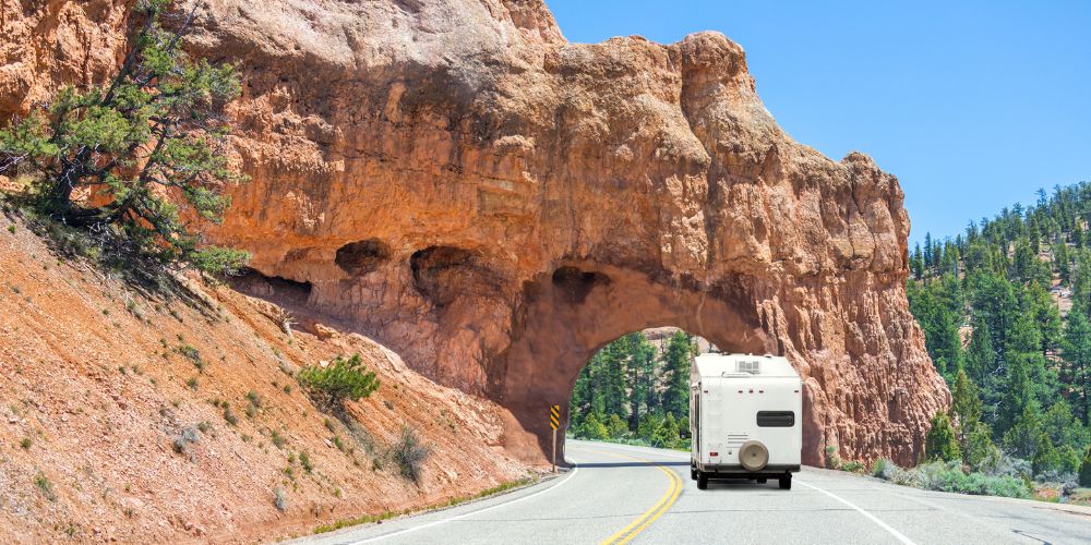
Grand Staircase–Escalante National Monument (Utah)
Grand Staircase–Escalante National Monument is best understood as a system rather than a destination. Spanning 1.7 million acres, it contains layered plateaus, entrenched river corridors, slickrock basins, and narrow canyons that together form one of the most geologically complete landscapes in North America, as documented by the BLM’s Grand Staircase–Escalante overview.
What distinguishes the monument is continuity. Its exposed sedimentary layers form one of the most complete stratigraphic records on the continent, a subject that has been extensively studied by the U.S. Geological Survey.
Access often begins along Hole-in-the-Rock Road or Cottonwood Canyon Road, which function more as gateways into complex terrain than as scenic drives. From there, routes branch into river corridors and canyon systems. Hikes along the Escalante River reveal rare combinations of water, shade, and canyon scale, while compact areas like Devil’s Garden provide concentrated geological detail.
Spring and fall offer the most reliable conditions. Summer travel requires caution due to heat and flash-flood risk, particularly in narrow drainages. Services remain limited to nearby towns such as Escalante and Kanab, reinforcing the need for self-sufficiency.
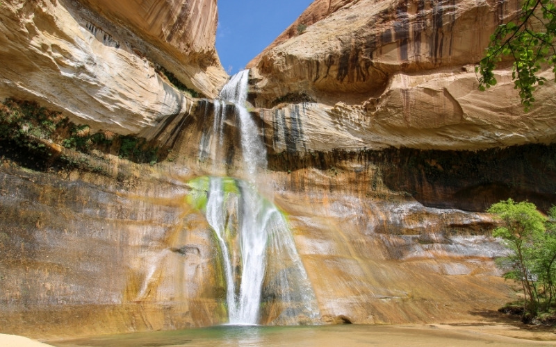
Pictured above is Lower Calf Creek Falls, one of the most iconic natural landmarks in Grand Staircase. This 126-foot waterfall at the end of a 6-mile, out-and-back hiking trail cascades into a deep, clear swimming hole surrounded by a lush desert oasis. The trail is famous for its towering Navajo sandstone cliffs and significant archaeological sites, including ancient pictographs and granaries.
Ironwood Forest National Monument (Arizona)
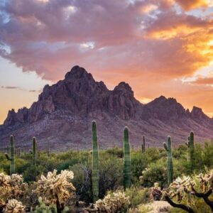 South and west of the Colorado Plateau, the landscape shifts noticeably. Ironwood Forest National Monument occupies a quieter corner of the Sonoran Desert, where broad valleys rise toward isolated mountain blocks. The monument’s ecological significance, particularly its ironwood populations, is detailed by the BLM’s Ironwood Forest resource page.
The monument protects one of the densest ironwood populations in the region, alongside extensive archaeological landscapes that predate modern boundaries. Rather than singular attractions, Ironwood Forest offers continuity: long washes, repeating saguaro silhouettes, and rugged peaks such as Ragged Top Mountain that anchor the horizon.
Exploration typically unfolds slowly along primitive roads, where subtle changes in terrain and plant communities become the primary points of interest. Seasonal conditions shape the experience strongly, with cooler months offering manageable temperatures and occasional wildflower blooms.
The monument has no developed facilities, and cell service is unreliable. Travel here favors preparation, navigation awareness, and minimal impact.
Organ Mountains–Desert Peaks National Monument (New Mexico)
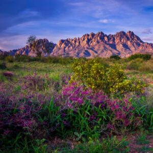 Moving east, the desert gives way to abrupt vertical relief. Organ Mountains–Desert Peaks National Monument rises sharply from the Chihuahuan Desert, its granite spires forming one of the most distinctive skylines in the Southwest. Land management and access details are maintained by the BLM New Mexico field office.
The Organ Mountains appear austere from a distance and reveal complexity through closer travel. The monument spans contrasting environments, from steep mountain terrain to open desert plains shaped by historic routes and mining activity.
Trails such as Baylor Pass Trail provide demanding crossings, while lower-elevation access points offer expansive views of the Organ Needles without requiring technical routes. These varying perspectives make the monument accessible in different ways, depending on conditions and experience.
Spring and fall are the most stable seasons, though weather shifts quickly at elevation. Wind exposure, temperature swings, and rugged footing are part of the landscape rather than exceptions to it.
Gold Butte National Monument (Nevada)
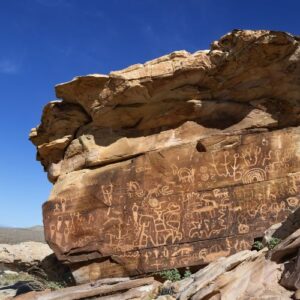 Farther west, infrastructure thins and distances expand. Gold Butte National Monument occupies a remote edge of the Mojave Desert, where sandstone formations, volcanic terrain, and Joshua tree forests intersect with significant rock art sites, as described in the BLM’s Gold Butte management summary.
The landscape resists simplification. Areas such as Whitney Pocket reveal bands of vividly colored sandstone, while Little Finland contains dense clusters of wind-carved forms shaped by erosion rather than access.
Roads are rough, distances are deceptive, and navigation is essential. Cultural history is inseparable from physical terrain here; petroglyph panels are embedded directly into the rock, reinforcing the reality that this land has long been inhabited and understood.
There are no services, no water sources, and no cell coverage. Travel depends entirely on preparation and restraint.
Mojave Trails National Monument (California)
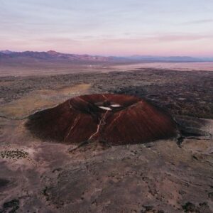 Continuing west, scale becomes the defining characteristic. Mojave Trails National Monument stretches across historic Route 66, preserving one of California’s largest intact desert landscapes under BLM management, detailed in the official monument overview.
Lava flows, sand dunes, and desert ranges coexist with remnants of transportation corridors and military use. Amboy Crater, a federally designated National Natural Landmark, is profiled by the National Park Service. Elsewhere, the Cadiz Dunes form an isolated system where wind, not visitation, dictates change.
The monument emphasizes movement through space rather than concentration around landmarks. Long drives between features reinforce the scale of the Mojave Desert and the planning required to travel it safely.
Winter through early spring offers the safest conditions. Summer heat is extreme, and services remain limited to small Route 66 communities along the monument’s margins.
Why These Places Matter
Taken together, these landscapes illustrate how the Southwest functions beyond park boundaries. They are not empty spaces between destinations, but records of geological processes and human presence measured in thousands of years.
Indigenous nations including the Southern Paiute, Hohokam, and Ancestral Puebloans maintained sustained relationships with these regions. Many cultural sites are protected under federal law, including the Antiquities Act of 1906.
Geologically, these monuments preserve processes that shaped the continent. Research from the U.S. Geological Survey continues to document how sedimentation, volcanism, and tectonics intersect across the Southwest.
Go Explore
Free-access desert monuments occupy a critical middle ground in the Southwest’s public-land system. They connect national parks, preserve large-scale ecological processes, and retain a level of openness that has become increasingly rare.
Travel in these landscapes requires more planning and fewer assumptions. In return, they offer a clearer view of how the region operates—geologically, culturally, and spatially—without the filters imposed by heavy infrastructure.
Seen together, these places form a continuous landscape rather than isolated destinations, one that rewards careful movement and sustained attention.